625 results
-


Oxford. Bodleian Library, BOD: Gough Gen. top. 220

- Collection
- Digital Bodleian (Oxford University)
- Library
- Oxford. Bodleian Library
- Date
- 1724
- Language
- English
-
Map of Buckinghamshire, with row of engravings of "British coins" in top and lower margin, in Herman
-

Oxford. Bodleian Library, G.A. Oxon 8o 246
- Collection
- Digital Bodleian (Oxford University)
- Library
- Oxford. Bodleian Library
- Date
- 1797
- Language
- English
-
Plan of Blenheim, the seat of the Duke of Marlborough, in Thomas Pride, New Description of Blenheim,
-

Oxford. Bodleian Library, Douce 218
- Collection
- Digital Bodleian (Oxford University)
- Library
- Oxford. Bodleian Library
- Date
- [1491-1492]
- Language
- English
-
Troilus and Criseyde.
-
The Canterbury Tales
-

Oxford. Bodleian Library, Savile K 6(4)
- Collection
- Digital Bodleian (Oxford University)
- Library
- Oxford. Bodleian Library
- Date
- 1564
- Language
- English
-
‘A prognostication of right good effect, fructfully augmented, contayninge … rules, to judge the wether
-

Oxford. Bodleian Library, OUM: 1 d. 88
- Collection
- Digital Bodleian (Oxford University)
- Library
- Oxford. Bodleian Library
- Date
- 1798
- Language
- Dutch, English, Latin
-
An outline of the Philosophy of Mineralogy, following the author's travels through Hungary, in anticipation
-

Paris. Bibliothèque interuniversitaire de la Sorbonne, R 2= 22. Pièce 33
- Collection
- NuBIS (Sorbonne)
- Library
- Bibliothèque interuniversitaire de la Sorbonne
- Date
- 1670, 17e s.
- Language
- eng
-
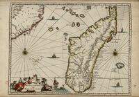
Carte publiée dans : Africa, being an accurate description of the regions of Ægypt, Barbary, Lybia, and
-

Oxford. Bodleian Library, MS. C17:48 (9), Sheet 7
- Collection
- Digital Bodleian (Oxford University)
- Library
- Oxford. Bodleian Library
- Date
- 1635
- Language
- English
-
Detail of part of Read Inge and Owld Park, with cattle and people
-

Oxford. Bodleian Library, OUM: 1 d. 41 Jurassic Rm
- Collection
- Digital Bodleian (Oxford University)
- Library
- Oxford. Bodleian Library
- Date
- 1757
- Language
- English
-
A study of fossils, mostly foreign, with descriptions of species, according to general characteristics
-

Oxford. Bodleian Library, (E) C17:70 Oxford (40)
- Collection
- Digital Bodleian (Oxford University)
- Library
- Oxford. Bodleian Library
- Date
- 1694-99
- Language
- English
-
Map of Port Meadow, two cartouches flanking 'The Prospect of Oxford from the North'; inset of St. martin's
-

Saint-Omer. Bibliothèque d'agglomération, inv. 2227
- Collection
- Bibliothèque de l'Agglomération du Pays de Saint-Omer
- Library
- Bibliothèque de l'Agglomération du Pays de Saint-Omer
- Date
- 17e siècle
- Language
- eng
-
-_Omer_Folio_Nevill_and_other_Marks_of_Ownership_--UPDATED_VERSION.
-

Oxford. Bodleian Library, Wood 276 b.fol. xxx
- Collection
- Digital Bodleian (Oxford University)
- Library
- Oxford. Bodleian Library
- Date
- 1644
- Language
- English
-
North of the city (with A for St. Giles Church) is at the bottom of the map. Scale c.1:10,000
-

Oxford. Bodleian Library, MS. Top. Oxon b. 167
- Collection
- Digital Bodleian (Oxford University)
- Library
- Oxford. Bodleian Library
- Date
- 1644
- Language
- English
-
Close-up of the map of the planned Oxford fortifications 13 November 1644. Scale c.1: 5,000
-

Oxford. Bodleian Library, MS. Arch. Seld. B. 10, fol. 184r
- Collection
- Digital Bodleian (Oxford University)
- Library
- Oxford. Bodleian Library
- Date
- c.1470-80
- Language
- Latin, English
-
Map with pictures of Ennermethe (Inverness), Seint Johnston (Perth), Abbey of Lindores, Abbey of Balmarino
-

Oxford. Bodleian Library, MS. Top. Oxon b. 167
- Collection
- Digital Bodleian (Oxford University)
- Library
- Oxford. Bodleian Library
- Date
- 1644
- Language
- English
-
Close-up of the map of the planned Oxford fortifications 13 November 1644. Scale c.1: 5,000
-

Oxford. Bodleian Library, MS. Top. Oxon b. 167
- Collection
- Digital Bodleian (Oxford University)
- Library
- Oxford. Bodleian Library
- Date
- 1644
- Language
- English
-
Close-up of the map of the planned Oxford fortifications 13 November 1644. Scale c.1: 5,000
-

Oxford. Bodleian Library, MS. Eng. th. f. 17
- Collection
- Digital Bodleian (Oxford University)
- Library
- Oxford. Bodleian Library
- Date
- 1627-1628
- Language
- English
-
England and Netherlands
-
A guide to prayer written while Augustine Baker was spiritual director to the community of English
-

Oxford. Bodleian Library, BOD: MAP RES 74 / Gough Maps 92
- Collection
- Digital Bodleian (Oxford University)
- Library
- Oxford. Bodleian Library
- Date
- 1610
- Language
- English
-
Extract from John Speed's Sussex in The theatre of the empire of Great Britaine, London.
-

Oxford. Bodleian Library, I 2.9 Med.
- Collection
- Digital Bodleian (Oxford University)
- Library
- Oxford. Bodleian Library
- Date
- 1638
- Language
- English
-
Title-page with a note recording payment of £1.10 to the painter who coloured the coats of arms thourghout
-

Oxford. Bodleian Library, Gough Maps Oxfordshire 2
- Collection
- Digital Bodleian (Oxford University)
- Library
- Oxford. Bodleian Library
- Date
- 1728, 1578
- Language
- Latin, English
-
Copy of the earliest map of Oxford by Ralph Agas, engraved by Augustine Ryther, in a reduced facsimile
-

Oxford. Bodleian Library, MS. Gough Maps 230
- Collection
- Digital Bodleian (Oxford University)
- Library
- Oxford. Bodleian Library
- Date
- 10th Sept., 1740
- Language
- English
-
"The Antidiluvian Sphere, 10th Sept., 1740 being the oldest picture in the world".
- Please select items from search results or item pages.
