526 results
-


Oxford. Bodleian Library, MS. Top. Oxon b. 167

- Collection
- Digital Bodleian (Oxford University)
- Library
- Oxford. Bodleian Library
- Date
- 1644
- Language
- English
-
Close-up of the map of the planned Oxford fortifications 13 November 1644. Scale c.1: 5,000
-
Oxford. Bodleian Library, Filmstrip Roll 235.5, frame 18
- Collection
- Digital Bodleian (Oxford University)
- Library
- Oxford. Bodleian Library
- Date
- 1707
- Language
- English
-
A large-scale portolan chart of the 100 mile navigation.
-

Oxford. Bodleian Library, MS. Dugdale 14
- Collection
- Digital Bodleian (Oxford University)
- Library
- Oxford. Bodleian Library
- Date
- Dated 1636
- Language
- English
-
Banner with Virgin of Mercy hung on the façade of the church. Shield with mitre, croziers and cross.
-

Oxford. Bodleian Library, Gough Maps Oxfordshire 19
- Collection
- Digital Bodleian (Oxford University)
- Library
- Oxford. Bodleian Library
- Date
- 1797
- Language
- English
-
Close-up of the inset map of the city of Oxford shows the western part from the River Isis with Osney
-

Oxford. Bodleian Library, Filmstrip Roll 364.1, frame 2
- Collection
- Digital Bodleian (Oxford University)
- Library
- Oxford. Bodleian Library
- Date
- 1697
- Language
- English
-
Close-up of the map of South China Sea and the Gulf of Siam by Augustine Fitzhugh, 1697
-

Oxford. Bodleian Library, Filmstrip Roll 235.5, frame 14
- Collection
- Digital Bodleian (Oxford University)
- Library
- Oxford. Bodleian Library
- Date
- 1697
- Language
- English
-
Portolan chart; Note, a few inches has been cut from the top, removing Bangkok
-

Oxford. Bodleian Library, Filmstrip Roll 235.5, frame 28
- Collection
- Digital Bodleian (Oxford University)
- Library
- Oxford. Bodleian Library
- Date
- 1697
- Language
- English
-
[South China Sea and the Gulf of Siam by Augustine Fitzhugh, 1697]
-

Oxford. Bodleian Library, Gough Maps Oxfordshire 19
- Collection
- Digital Bodleian (Oxford University)
- Library
- Oxford. Bodleian Library
- Date
- 1797
- Language
- English
-
Close-up of inset map with the High Street, Holywell and St Clement's, in Richard Davis, A map of the
-

Oxford. Bodleian Library, Filmstrip Roll 235.5, frame 22
- Collection
- Digital Bodleian (Oxford University)
- Library
- Oxford. Bodleian Library
- Date
- 1660
- Language
- English
-
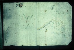
[Portolan chart of the North Atlantic Ocean by John Burston]
-

Oxford. Bodleian Library, MS. Dugdale 28
- Collection
- Digital Bodleian (Oxford University)
- Library
- Oxford. Bodleian Library
- Date
- dated 1605
- Language
- English
-
A consideration of the office and duty of heralds in England…'.
-

Saint-Omer. Bibliothèque d'agglomération, 4749-7
- Collection
- Bibliothèque de l'Agglomération du Pays de Saint-Omer
- Library
- Bibliothèque de l'Agglomération du Pays de Saint-Omer
- Date
- 1729
- Language
- eng
-
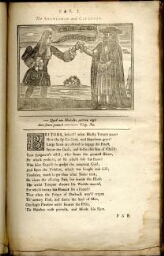
The fable of the crafty statesman and subtle cardinal. II. The Passive Goose. III.
-


Cambridge. Corpus Christi College, Parker Library MS 233
- Collection
- Parker Library On the Web (Cambridge)
- Library
- UK, Cambridge, Corpus Christi College, Parker Library
- Date
- 1400 - 1499
- Language
- lat, eng
-
strong>CCCC MS 233 is a compendium of grammatical, didactic and devotional works copied in a cursive hand
-

Cambridge. Corpus Christi College, Parker Library MS 582
- Collection
- Parker Library On the Web (Cambridge)
- Library
- UK, Cambridge, Corpus Christi College, Parker Library
- Date
- 1574
- Language
- lat, eng
-
gifts of furniture for the use of the Norwich scholars.
-

Oxford. Bodleian Library, Vet. A3 b.10
- Collection
- Digital Bodleian (Oxford University)
- Library
- Oxford. Bodleian Library
- Date
- 1675
- Language
- English
-
Map title of the first English road atlas, with putti and horsemen with surveyors' instruments, a chain
-


Paris. Bibliothèque interuniversitaire de la Sorbonne, VCM 6= 5723
- Collection
- NuBIS (Sorbonne)
- Library
- Bibliothèque interuniversitaire de la Sorbonne
- Date
- 1651, 17e s.
- Language
- eng
-
Letters between the Ld George Digby, and Sr Kenelm Digby kt. concerning religion.
-


Cambridge. Trinity Hall Library, MS 17
- Collection
- Cambridge Digital Library
- Library
- Cambridge. Trinity Hall Library
- Date
- c.1395
- Language
- Latin and English
-
Many people among the higher echelons of English society supported the views of the Lollards, including
-

Oxford. Bodleian Library, BOD: Gough Maps 86
- Collection
- Digital Bodleian (Oxford University)
- Library
- Oxford. Bodleian Library
- Date
- 1689
- Language
- English
-
Chart of the Dee estuary - eastern half
-

Oxford. Bodleian Library, BOD: Gough Maps 112
- Collection
- Digital Bodleian (Oxford University)
- Library
- Oxford. Bodleian Library
- Date
- 1719
- Language
- English
-
Road map from Thomas Gardner, A Pocket-Guide to the English Traveller ...
-

Cambridge. Corpus Christi College, Parker Library MS 329
- Collection
- Parker Library On the Web (Cambridge)
- Library
- UK, Cambridge, Corpus Christi College, Parker Library
- Date
- 1400 - 1425
- Language
- lat, eng
-
Written c. 1425-50, the manuscript contains a number of texts associating it with the priory of the Blessed
-

Oxford. Bodleian Library, Filmstrip Roll 364.1, frame 4
- Collection
- Digital Bodleian (Oxford University)
- Library
- Oxford. Bodleian Library
- Date
- 1697
- Language
- English
-
Close-up of the portolan chart of the South China Sea and the Gulf of Siam by Augustine Fitzhugh, 1697
- Please select items from search results or item pages.
