625 results
-


Oxford. Bodleian Library, MS. Sherard 244

- Collection
- Digital Bodleian (Oxford University)
- Library
- Oxford. Bodleian Library
- Date
- 1787–1794
- Language
- Latin, English
-
966 watercolours of plants collected in 5 volumes (see also MSS. Sherard 241-243, 245).
-

Oxford. Bodleian Library, J Maps 224 [85]
- Collection
- Digital Bodleian (Oxford University)
- Library
- Oxford. Bodleian Library
- Date
- 1768
- Language
- English
-
Plan of proposed canal, covering parts of Warwickshire, Northamptonshire and Oxfordshire.
-

Oxford. Bodleian Library, MS. Sherard 241
- Collection
- Digital Bodleian (Oxford University)
- Library
- Oxford. Bodleian Library
- Date
- 1787–1794
- Language
- Latin, English
-
966 watercolours of plants collected in 5 volumes (see also MSS. Sherard 242-245).
-

Oxford. Lincoln College, LC/R/1
- Collection
- Digital Bodleian (Oxford University)
- Library
- Oxford. Lincoln College
- Date
- 1472–1640
- Language
- Latin, English
-
Begun by William Bethome (Fellow 1474-9, Bursar 1476; Rector 1488 - 1493) to keep copies of charters,
-

Oxford. Bodleian Library, J Maps 224 [10]
- Collection
- Digital Bodleian (Oxford University)
- Library
- Oxford. Bodleian Library
- Date
- 1610
- Language
- English
-
Map of the county with inset map of Oxford and framed by college shields
-

Oxford. Bodleian Library, Filmstrip Roll 199D, frame 4
- Collection
- Digital Bodleian (Oxford University)
- Library
- Oxford. Bodleian Library
- Date
- 1673
- Language
- English
-
Map of Buckinghamshire at 1:187,500 in Richard Blome, Britannia: or, A geographical description of the
-

Oxford. Bodleian Library, BOD: Allen 10
- Collection
- Digital Bodleian (Oxford University)
- Library
- Oxford. Bodleian Library
- Date
- 1698
- Language
- English
-
Road map from Britannia: or, the Kingdom of England and Dominion of Wales ... by John Ogilby.
-

Oxford. Bodleian Library, BOD: Gough Maps 100
- Collection
- Digital Bodleian (Oxford University)
- Library
- Oxford. Bodleian Library
- Date
- 1675
- Language
- English
-
Road map from John Ogilby, Book of Roads, The Principal Road-ways of His Majesty's Kingdom of England
-


Cambridge. Corpus Christi College, Parker Library MS 491
- Collection
- Parker Library On the Web (Cambridge)
- Library
- UK, Cambridge, Corpus Christi College, Parker Library
- Date
- 1700 - 1725
- Language
- lat, eng
-
Summary: CCCC MS 491 is the first of two volumes of the autograph notes of William
-


San Marino. The Huntington Library, DE 1
- Collection
- Huntington Digital Library
- Library
- The Huntington Library
- Date
- February 22, 1781
- Language
- English [eng]
-
Washington expresses gratitude for Destouches' (and French) assistance and discusses strategic placements
-

Oxford. Bodleian Library, Filmstrip Roll 190J, frame 1
- Collection
- Digital Bodleian (Oxford University)
- Library
- Oxford. Bodleian Library
- Date
- 1575
- Language
- English
-
From Atlas of the counties of England and Wales - scale c.1: 250,000
-

Oxford. Bodleian Library, Douce B 248 (3-4)
- Collection
- Digital Bodleian (Oxford University)
- Library
- Oxford. Bodleian Library
- Date
- 1565
- Language
- English
-
Engraving with man in profile in oval medallion; details regarding the previous section. titlepage of
-

Oxford. Bodleian Library, MS. Rawl. B. 87
- Collection
- Digital Bodleian (Oxford University)
- Library
- Oxford. Bodleian Library
- Date
- 17th century, beginning
- Language
- English
-
England and Netherlands
-
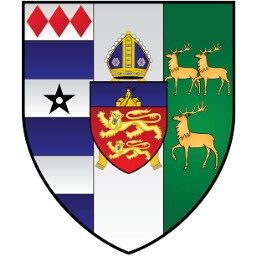
Coat of arms of Allen Epes, of the isle of Thanet, attested by 'Will[ia]m Segar, Garter principall king
-

Oxford. Bodleian Library, BOD: Gough Maps 100
- Collection
- Digital Bodleian (Oxford University)
- Library
- Oxford. Bodleian Library
- Date
- 1675
- Language
- English
-
Road map from John Ogilby, Book of Roads, The Principal Road-ways of His Majesty's Kingdom of England
-

Paris. Bibliothèque nationale de France, Département des manuscrits, Anglais 45
- Collection
- Gallica (Bibliothèque nationale de France)
- Library
- Paris. Bibliothèque nationale de France, Département des manuscrits
- Date
- XVIIe siècle
- Language
- anglais
-
« In the name of Our Lord here beginneth the Rule of the Nuns of the Conception of the blessed Virgin
-

Oxford. Bodleian Library, MS. Sherard 242
- Collection
- Digital Bodleian (Oxford University)
- Library
- Oxford. Bodleian Library
- Date
- 1787–1794
- Language
- Latin, English
-
966 watercolours of plants collected in 5 volumes (see also MSS. Sherard 241, 243-245).
-

Oxford. Bodleian Library, Filmstrip Roll 199D, frame 2
- Collection
- Digital Bodleian (Oxford University)
- Library
- Oxford. Bodleian Library
- Date
- 1634
- Language
- English, Latin
-
Saxton map published 1634, with only boundaries coloured, in 'Atlas of the counties of England and Wales
-

Oxford. Bodleian Library, Douce F 203
- Collection
- Digital Bodleian (Oxford University)
- Library
- Oxford. Bodleian Library
- Date
- 1586
- Language
- English
-
England and Netherlands
-
Coat of arms of Anne, wife of Richard II.
-

Oxford. Bodleian Library, MS. Ashmole 850
- Collection
- Digital Bodleian (Oxford University)
- Library
- Oxford. Bodleian Library
- Date
- 1664-1666
- Language
- Latin, English
-
England and Netherlands
-
Coats of arms.Part of three volumes compiled and written by Elias Ashmole (see also MSS.
-

Oxford. Bodleian Library, Filmstrip Roll 190J, frame 2
- Collection
- Digital Bodleian (Oxford University)
- Library
- Oxford. Bodleian Library
- Date
- 1575
- Language
- English
-
From Atlas of the counties of England and Wales: 'Cantii, Southsexiae, Surriae et Middlesexiae Comitat
- Please select items from search results or item pages.
