522 results
-


Oxford. Bodleian Library, Filmstrip Roll 271.1, frame 4

- Collection
- Digital Bodleian (Oxford University)
- Library
- Oxford. Bodleian Library
- Date
- 1797
- Language
- English
-
Title of map with Davis' signature above the scale and No 34 in the corner indicating that this was a
-

Oxford. Bodleian Library, BOD: MAP RES 80 / fol. BS. 45
- Collection
- Digital Bodleian (Oxford University)
- Library
- Oxford. Bodleian Library
- Date
- 1574
- Language
- English, Latin
-
medium-scale map of these counties: scale of one inch to 3 miles 16 chains, from Saxton's atlas of England and
-


San Marino. The Huntington Library, HM 587
- Collection
- Huntington Digital Library
- Library
- The Huntington Library
- Date
- Sept. 28 - Dec. 5, 1783
- Language
- English [eng]
-
Regimental orderly book consisting mainly of records of courts martial, with some regimental, garrison, and
-

Oxford. Bodleian Library, MS. Gough Maps 230
- Collection
- Digital Bodleian (Oxford University)
- Library
- Oxford. Bodleian Library
- Date
- 10th Sept., 1740
- Language
- English
-
(Adam shown identified with Prometheus and Hercules).
-

Oxford. Bodleian Library, (E) C17:49 (36)
- Collection
- Digital Bodleian (Oxford University)
- Library
- Oxford. Bodleian Library
- Date
- 1750
- Language
- English
-
Map with conical projection: county and hundred boundaries, hills, roads, woods etc., in the first issue
-

Oxford. Bodleian Library, MS. Rawl. C. 136
- Collection
- Digital Bodleian (Oxford University)
- Library
- Oxford. Bodleian Library
- Date
- 1724
- Language
- English
-
Rawlinson of printed and manuscript material relating to the Freemasons.
-

Oxford. Bodleian Library, Filmstrip Roll 235.5, frame 24
- Collection
- Digital Bodleian (Oxford University)
- Library
- Oxford. Bodleian Library
- Date
- 1670
- Language
- English
-
Decorated scale and compass-rose in close-up from Nicholas Comberford's portolan chart, MAP RES 118 /
-

Oxford. Bodleian Library, Filmstrip Roll 271.1, frame 8
- Collection
- Digital Bodleian (Oxford University)
- Library
- Oxford. Bodleian Library
- Date
- 1797
- Language
- English
-
symbols for water mills in less than five miles, two are specifically identified as a fulling mill and
-

Oxford. Bodleian Library, G.A. Eng. rds. 8o 92
- Collection
- Digital Bodleian (Oxford University)
- Library
- Oxford. Bodleian Library
- Date
- 1720
- Language
- English
-
Text with map of Oxfordshire, and strip map of the road from Bristol to Cirencester, in John Owen, 'Britannia
-

Oxford. Bodleian Library, Filmstrip Roll 271.1, frame 9
- Collection
- Digital Bodleian (Oxford University)
- Library
- Oxford. Bodleian Library
- Date
- 1797
- Language
- English
-
Wootton hundred with Woodstock and Blenheim Park.
-

Saint-Omer. Bibliothèque d'agglomération, 4749-7
- Collection
- Bibliothèque de l'Agglomération du Pays de Saint-Omer
- Library
- Bibliothèque de l'Agglomération du Pays de Saint-Omer
- Date
- 1729
- Language
- eng
-
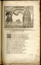
The fable of the crafty statesman and subtle cardinal. II. The Passive Goose. III.
-
Oxford. Bodleian Library, Filmstrip Roll 235.5, frame 18
- Collection
- Digital Bodleian (Oxford University)
- Library
- Oxford. Bodleian Library
- Date
- 1707
- Language
- English
-
The walled city was defended by forts along the river, and a 'Lazarus Plaats' to guard the city's health
-

Oxford. Bodleian Library, BOD: Gough Maps 100
- Collection
- Digital Bodleian (Oxford University)
- Library
- Oxford. Bodleian Library
- Date
- 1675
- Language
- English
-
Road map from John Ogilby, Book of Roads, The Principal Road-ways of His Majesty's Kingdom of England and
-

Oxford. Bodleian Library, MS. Ashmole 834, pt III
- Collection
- Digital Bodleian (Oxford University)
- Library
- Oxford. Bodleian Library
- Date
- 1563
- Language
- English
-
Pen and ink drawings. Coats of arms.
-

Oxford. Bodleian Library, Filmstrip Roll 271.1, frame 13
- Collection
- Digital Bodleian (Oxford University)
- Library
- Oxford. Bodleian Library
- Date
- 1797
- Language
- English
-
Detached part of Chadlington Hundred bordering Bampton and Wootton Hundreds.
-

Oxford. Bodleian Library, BOD: Gough Maps 100
- Collection
- Digital Bodleian (Oxford University)
- Library
- Oxford. Bodleian Library
- Date
- 1675
- Language
- English
-
Road map from John Ogilby, Book of Roads, The Principal Road-ways of His Majesty's Kingdom of England and
-

Oxford. Bodleian Library, BOD: Gough Maps 100
- Collection
- Digital Bodleian (Oxford University)
- Library
- Oxford. Bodleian Library
- Date
- 1675
- Language
- English
-
Road map from John Ogilby, Book of Roads, The Principal Road-ways of His Majesty's Kingdom of England and
-

Oxford. Bodleian Library, (E) C17:70 Oxford (20)
- Collection
- Digital Bodleian (Oxford University)
- Library
- Oxford. Bodleian Library
- Date
- 1643
- Language
- English
-
City plan with insets: map of surrounding countryside and a view of the city.
-

Oxford. Bodleian Library, J Maps 224 [85]
- Collection
- Digital Bodleian (Oxford University)
- Library
- Oxford. Bodleian Library
- Date
- 1768
- Language
- English
-
Plan of proposed canal, covering parts of Warwickshire, Northamptonshire and Oxfordshire.
-

Oxford. Bodleian Library, Gough Maps Oxfordshire 19
- Collection
- Digital Bodleian (Oxford University)
- Library
- Oxford. Bodleian Library
- Date
- 1797
- Language
- English
-
Close-up of inset map with the High Street, Holywell and St Clement's, in Richard Davis, A map of the
- Please select items from search results or item pages.
